03 July, 2021

North Battleford to Stony Plain, day 8

 It was another bright and early start for us on our last westward bound leg of the trip. We has been the only boondocker in the parking lot overnight but now a few people were turning up to walk dogs or just exercise at the park on this beautiful day. Before joining the highway we headed to the Wal Mart shopping centre and gassed up and then joined highway 16 once again.

We crossed the Saskatchewan / Alberta in Lloydminster at 9.20am and travelled on to Vermillion where we celebrated with a Tim's coffee and doughnut.

We could hardly pass Vegreville without stopping in so we called into Kinsmen/Elk Park for some pictures at the lake and Pysanka.


We even managed to make it look like the trailer was still flying a Canadian flag as we did in Manitoba, albeit a bit smaller version.

After a while it was back in to the car and head off on this westward final final leg. We topped up with gas and headed for Stony Plain. Driving the highway along the northern edges of Edmonton was the busiest section of highway we'd encountered all the way. Regardless, we arrived at our Stony Plain destination incident free shortly after 2pm, YEAH!
We drove 431km this final day for a total of 3833km at an average speed of 73km/hr and 52 and a half hours of actual driving and around 700 litres of gas.
Time for a rest.


02 July, 2021

Moosomin Regional Park to North Battleford, day 7

 Having made such good progress yesterday we were excited that our westward journey now had a n end almost insight. Despite the late night last night we were up at 6 and after a leisurely breakfast and tear down we left the site at 7.45am.

We filled up with gas in the town of Moosomin itself before rejoining highway 16 west.

After about 3 hours we decided on a coffee break. Our GPS informed us there was a rest area not too far away so we kept our eyes peeled for that. We soon spotted it and pulled to the entrance right on the side of the highway only to find a barrier across the entrance and it was no place to be stopping for anything. We quickly pulled out again and another rest area search revealed there was another a little further west, just off the highway. We were becoming all too aware that once again our fuel gauge was getting down to about 60km of fuel left.

We took highway 2 (north) and continued north for several kilometres looking for the rest area which proved to be at the bottom of a small valley where the road wound downhill from both sides of the valley. This picture does not do the downhill aspect of the road justice!


The picture shows the road coming from the opposite direction from which we approached the rest area. The picture was taken to show the small river and in particular a couple of turtles on the rock in the centre of the picture. I believe they were Blandings turtles. I did not want to get too close as they'd likely disappear into the water.


We didn't need to get too close to realise this rest area didn't look to be too hopeful. The building, even from a distance, could be seen to be somewhat derelict and as we got to the entrance the barrier was once again chained and locked. Fortunately the entranceway was sufficiently large enough for us to just about pull in off the road and take our break which we were grateful even though traffic from both directions came downhill towards us, with traffic from our side of the having less visibility of us because of a bend in the road. Being a minor road the traffic was quite light. This little closed rest area was quite scenic and peaceful in the circumstances.

Having had a rest we set off again but since our GPS informed us it was more than 70km north-west (the way we were headed) to a gas station we decided not to take the risk and head back a few kilometres to Findlater where we'd seen a gas station on the other side of the highway. We were not happy when, after doubling back for gas, we discovered the gas station was 'temporarily' closed. Just up the road where we were going to rejoin the highway were a few bikers who were taking a break. We asked them about gas stations and they told us there was one less than 15km away in the town of Chamberlain that we were passing through anyway. I guess local knowledge beats GPS knowledge sometimes! Sure enough, we headed NW to Chamberlain and found the gas station even if it was quite busy but that should be expected if they are few and far between. Next to the gas station was this statue of an early pioneer and across the street is this typical grain elevator.


Having refuelled the car we travelled north-west again for a couple of hours before coming across a sign for a rest area that we thought would be OK for a lunch stop. We followed the picnic table signs only to be led to Blackstrap provincial Park where we had to pay an entry fee even though we just wanted an hours stop to eat some lunch. The side roads are just too narrow and have few if any spots suitable for turning around so we had to bite the bullet and pay our entry fee. At least tonight I was hoping that we could try our hand at our first boondocking spot. I had tentatively thought about going to a campground in Maidstone, SK, but that seemed a jus bit to far. I little research from the website www.ioverlander.com showed that we may be able to boondock at a civic park in North Battleford, SK. Arriving in North Battleford around 6pm we headed to McD's where we purchased some food then set out into the town's back streets in search of the park we planned to spend the night. It turned out o be an excellent park, a large, gravelled parking lot overlooking a sports field as well as lots of good quality parkland.

Today was another personal best at 724km! That does seem a little high as Google tells me the distance between the two is about 630km but maybe that's price of our gas and rest stop detours?


30 June, 2021

Aaron Provincial Park to Moosomin Regional Park, day 6

 We knew it could be a long day when we got up at 6am thinking it was 7am but we'd forgotten about the extra hour we got yesterday when we crossed into Central time. So we actually left the campground at 7.30am on our westward journey. From this point on we had not booked any campgrounds as we weren't sure how far we'd get each day.

Crossed into Manitoba at 9.50am with the original intention of overnighting at Bird's Hill Campground near Winnipeg. However as that would be a drive of only (?) 369km we thought we could get further than that, even more so after our earlier than planned start.

By now we had discovered that gas stations can be few and far between with the result that a couple of times we'd been down to the car showing we only had around 30km worth of gas in the tank and we'd better find a gas station PDQ if we weren't to run out. Naturally, when you find one gas station you find several! Getting low on gas we pulled into a Shell gas station and attempted to gas up only to find my credit card declined - oh no 🤯! We pulled away from the pumps and called the bank who told us there was no problem with the card and their system didn't even register a couple of failed attempts. The service agent was confident it was a gas station issue rather than our card giving problems. So we were able to pull forward less than 50 metres in to the adjacent Esso gas station where the card worked seamlessly. 

The countryside along the highway seemed to be opening up now, still plenty of trees but not as dense as before. Additionally, since we are now on a four lane highway (2 each direction!) there is naturally more space as well as it tending to be straighter, flatter and faster road.

As we approached Winnipeg we came across a sign indicating we were at the longitudinal centre of Canada. Parking was a little tricky as the parking lot was quite small and I couldn't park on the service road. I did manage to reverse into the parking lot and even managed to make it look like we were flying a Canadian flag from trailer roof!


We were making good progress but still had nowhere booked to stay tonight. Stopping at a Walmart to buy some batteries we took advantage of their internet to research where we might stop and made a few notes. We crossed in to Saskatchewan at 7.09 pm (note tht we crossed Manitoba in a day - took us 4 days to get out of Ontario!). Entering the town of Moosomin we spotted a sign to a campground that we though was close to the highway. After about 18km and several small, rough and winding roads later we finally arrived at Moosomin Regional Park. Fortunately the campground had vacancies although we were informed that the site was fully booked for the following night, not that that bothered us.

We checked in and headed down to our 'almost lakeside' site with electric and water hookup available.


Having driven our personal best of 704km in a day we were well pleased with the day's effort. Some nice cloud formations were on display.....
We explored the park a little and found the park store (with internet access) as well as a sizeable beach and playground but also quite a few solidly built cottages (holiday homes) making quite a sizeable summer community here. Maybe due to the late arrival at the campground, a late supper, talking with some residents or maybe just because it never seems to get dark here it was gone 11pm by the time we turned in for the night. This beach photo was early the next day, the sun was not quite high enough for a better photo......but high enough for us to be setting off again.


Rainbow Falls Provincial Park to Aaron Provincial Park, days 4 & 5

 After a good nights sleep we rose at 6.45am and set about the routine of wash, breakfast and get ready to roll.

Before leaving the site we drove to a parking lot in the campground, walked down 172 steps to get a view of the parks namesake waterfall 


before heading back to the car, dumping the grey and black tanks and heading west back on the Trans Canada Highway.

The drive was consistently interrupted by roadworks with one side of the highway completely closed, sometimes for kilometres at a time. Traffic flow was controlled by workers holding stop/slow signs. Another sign we saw of a bit more interest indicated that we were passing the smallest Canadian Tire store in Canada. A pit stop for gas in Thunder Bay was followed by a lunch an hour earlier than planned as we took the stop at the rest area where we crossed in Central Time. 


Arrived at Aaron Provincial Park (just east of Dryden, Ontario) at 4.45pm having completed almost 520km today. We had booked a two night stopover here as we anticipated we may need a break from driving too much every day. As it turned out it was a godsend to have a break as the oil change warning light came on earlier in the day and having a longer stay here would allow us to get the oil change done without adversely affecting our schedule.

Despite the employee at the park office telling us where the potable water when we arrive at the water tap there was a sign informing us that the water was not potable. We drove around the site, trailer in tow, checking out all the water taps but they were all tagged as non-potable - do not use. Fortunately we do carry potable water in a 10L container as well as a pack of 24 individual 500ml water bottles. Just after setting up we had a thunder and lightening storm. Roast beef, broccolli, new potatoes, gravy and a glass of cider for supper - just needed some Yorkshire puds and horseradish to be perfect.


After breakfast the next day we set off the 15km into Dryden to try to get an oil change done. The only place in town seemed to be the Canadian Tire store who booked the car in for 4pm that same day. Being in the same town for a whole day also gave us the opportunity to get a prescription filled as well as look around the town itself.

Dryden seems like a nice town, originally built around a paper mill industry and a paper mill is still operational there today. Having a paper mill in town of course means another river,


a small waterfall and even a suspension bridge. 


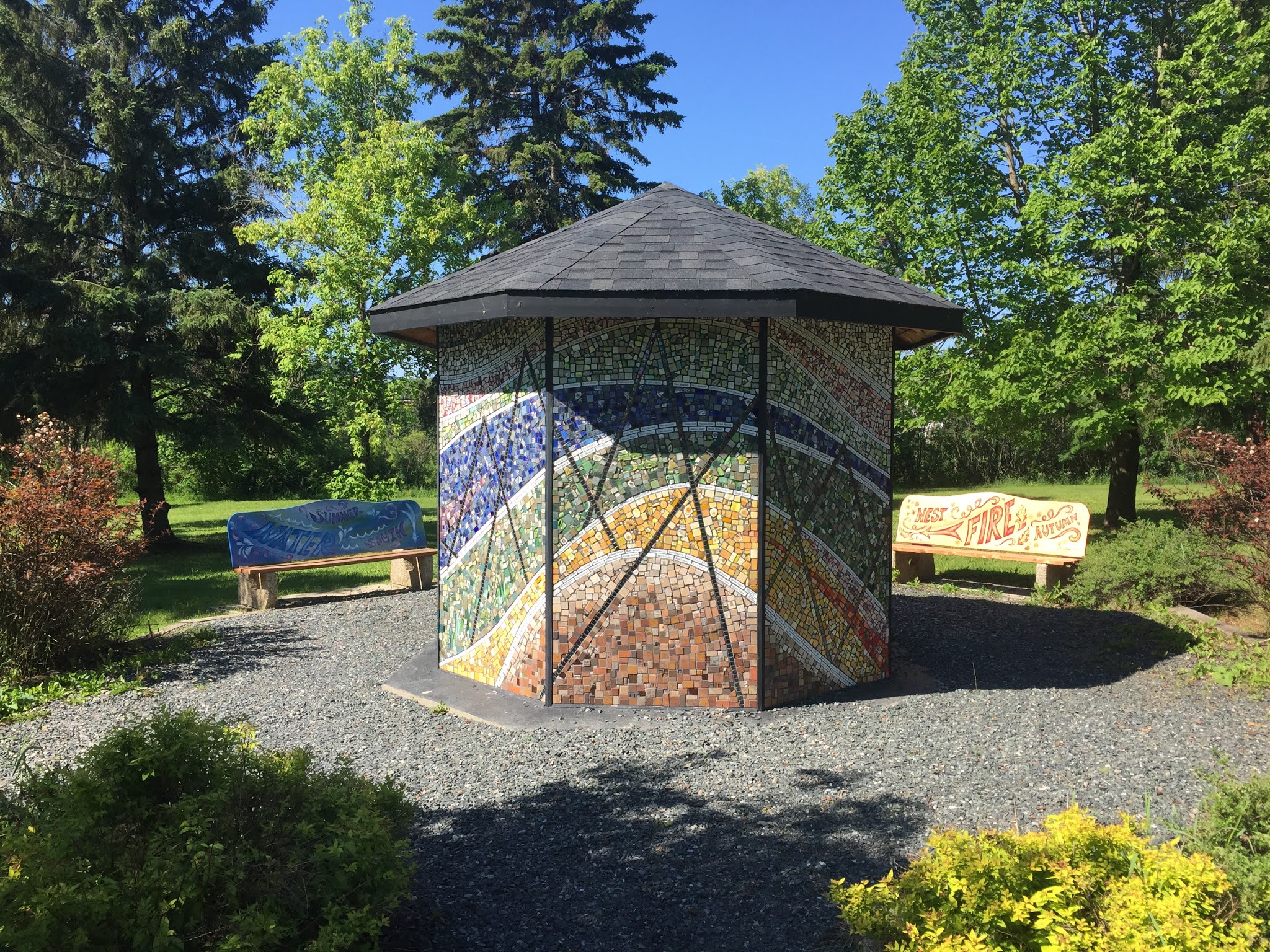
At the park adjacent to the river/suspension bridge is a very nice piece of artwork called 'Pieces of Dryden'. It's central feature is an hexagonal structure comprised of around 18000 pieces of broken pottery and glass etc. contributed by the citizens of Dryden. The structure is encircled by benches with various designs.


After exploring town we headed back to the campground, packed a lunch and headed to the lakeside for lunch and a couple of hours fruitless fishing. Then it was back into Dryden for the oil change appointment and also bought some marine grade caulk for the trailer window. Back to campground for a bolognaise supper, caulked the trailer window and tidied the trailer ready for the off in the morning.


29 June, 2021

Ivanhoe Lake PP to Rainbow Falls PP, day 3

Getting used to setting up and pulling the trailer now. We seem to have taken on the various tasks that need to be done when setting up and tearing down. So breaking camp now was a routine affair and we became so efficient we managed to set off at 8am. Continuing to head west on highway 101 before joining the Trans Canada (hwy 17) again and following the shore of Lake Superior.

The first section of road proved to be quite hilly with lots of twists. It's a nice road but not one to take if you're in a hurry. I ha chosen this route instead of the more northerly route (via Cochrane) simply because there were no available campsites on the Cochrane route. I could instead have chosen the southern route through Sudbury but the plan is to take that route on the homeward leg.

Since we were travelling a less popular route traffic was even lighter than usual and rounding one curve I don't know who was more surprised - us or the black bear towards the side of the road! The bear ran on to a slope on the right hand side of the road where it stopped and gazed at us over it's right shoulder. Not for the first time we couldn't hit the brakes for a picture (well I could have done but considered it too risky with a trailer and limited visibility as to what might be behind us). 


                                I guess this will have to do 😀


Happy to see the bear, we were on high alert to make sure we got a real picture next time but on this trip there was to be no next time. We pulled into the town of Wawa where we gassed up the car and pulled into a 'no parking' zone at the side of the highway outside of another Tim Horton's for coffee and donuts. The Tim's parking lot was just to small to pull into there and we needed a coffee. We pulled up behind another trailer much to the annoyance of someone in Tim's who didn't like us parking there. A couple of minutes later though we pulled out and stopped at the visitor centre which is just a couple of kilometres along the road to enjoy the coffee and donuts. 


Wawa is of course home to the Wawa goose, which proudly stands on a rock at the tourist information office. Wawa means 'land of the big goose' in the indigenous Ojibwe language. The goose monument was the idea of local entrepreneur Al Turcott. Although not originally from Wawa, Al first came to the town in 1939 for work and became so fascinated by the area that he sent for his wife and children to join him. By the 1940s, Al began operating Turcott's Dry Goods and Clothing store and became very involved in the community. So much so, that Al played an essential role in securing the Lake Superior route of the then proposed route of the Trans Canada Highway through Wawa. Concerned because the final plans had the highway bypassing Wawa, Al and other local businessmen created the idea of the Goose Monument to stop tourists on their TransCanada trips. The original goose was made of plaster and, upon pushing a button, it could talk to you. However the plaster could not stand up to the harsh winters and was replaced in 2017 by a new goose made from steel. The current goose is 28 feet tall, 22 feet long and has a wingspan of 20 feet.


Once the coffee and donuts were disposed off we piled back in the car and set off for the town of White River. It didn't take use long to reach there and although we didn't stop on this hop we did get a few photographs of Lake Superior from the highway.


 Having stopped at White River for lunch we discovered that the town is the original home of Winnie the Pooh (named after Winnipeg, Manitoba) with the requisite larger than life model.  Hopped back into the car again at 1.55pm.


After another refueling stop at Terrace Bay we arrived at the White Lake campground area of Rainbow Falls provincial park at 4.25pm. Our site was identified as W48 on our reservation but the campground office was closed. We could find no specific site that was identified as W48 but after calls to the Ontario Parks reservation service and then to Gill who was able to get online and look at a map of the campground we decided the site was just plain old 48. Having set up the trailer we went for a walk to the lookout and captured this video and the campground beach.


28 June, 2021

Finlayson Point PP to Ivanhoe Lake PP, day 2

 Monday 21st June we set off from Findlayson Point PP in the rain and got as far as Temiskaming Shores to get more 'must have' trailer accessories from Canadian Tire. We were pleased that when we came out of CT it had stopped raining although unfortunately the rain soon started again and was heavier than previously. We passed a gas station named 'Corner Gas' but not the same gas station as it's more famous namesake from the TV series. The rain continued pretty hard at times and visibility was not helped by the spray coming from the passing truckers in their big rigs.

Passing a huge bison model (sorry going too fast or a picture), we stopped for lunch at Tim's (Horton's) in Timmins, where else?

Arrived at Ivanhoe Lake provincial park at 3.15pm. where the rain had stopped but it was cold at only 5C so tonight it would be the turn of the furnace to keep us comfortable after using the A/C last night. We discovered that some bedding had become wet as the driving rain had entered the trailer through the forward facing window. Fortunately the camp ground had a laundromat so we were able to dry the few things in the dryer. Another item we need to add to a shopping list - caulk for the window 😣


Much had been made of the campgrounds being fully booked right through the summer but we were surprised at how quiet they actually were. The camp ground was less than 1/3 full with people staying although a lot of sites were occupied by trailers that were obviously parked there for the season but the actual campers look like they only turn up on weekends or in school vacations.


We did get to talk to one camper who was from Orleans and he gave us the name of the location he uses in Cumberland for trailer storage and recommended it to us but urged us not to delay booking a storage site as the spaces fill quickly.
Later that evening the sun came out and although the next morning it was still chilly but at least the sun was shining 🌞 for the next travel leg....